

Ambra Garancini, President of Iubilantes and Rete dei Cammini seen superimposed on the cover photo of her recent publication ‘La Via Francigena Renana’.
Congratulations are due to Ambra Garancini and the cultural association ‘Iubilantes’ on the recent publication of ‘La Via Francigena Renana a Piedi’. This book – the fruit of many years of research – is a guide to walking one of the lesser known but historically significant transalpine routes. The book offers walkers practical information and a detailed cultural guide covering the section of this long-distance trail starting in Chur (Coira in Italian) – the capital of the Swiss Grisons – and ending on the southern border of Lombardy on the banks of the Po at Corte Sant’ Andrea. Its publication marks the rediscovery and promotion of a long distance trail first recorded in Roman times that ran from the mouth of the Rhine in Rotterdam, over the Alps at Splugen, to the Po where it linked up with the other Via Francigena on its way to Rome.
What is the Via Francigena Renana?

The Via Francigena Renana runs the length of the Rhine from its mouth in Rotterdam to cross the Alps at the Splugen Pass and to continue on to Rome having passed Como and Milan.
Visitors to the Val D’Aosta and Piedmont may well be aware of or have noticed signs for the Via Francigena. However there are a number of Vie Francigena with the name ‘Francigena’ signifying ‘coming from France or Germany’. Ambra’s new book focuses on the ‘Via Francigena Renana’ with ‘Renana’ referring to the Rhine. As such, the trail starts in Rotterdam at the mouth of the Rhine and follows the river’s course to Cologne, Mannheim and then down the Franco-Germanic borderlands to Strasbourg and Basle before continuing down the southern shores of Lake Constance to Chur. At Reichenau, just to the west of Chur, the path takes the southern fork of the Rhine known as the ‘Hinterrhein’ (known in Italian as the Reno Posteriore) before turning off at Splugen to cross the Alps over the Splugen Pass and the dramatic gorge known as the Via Mala. Once over the Splugen Pass, the route continues on to Chiavenna and then down the western shores of Lake Como to Como itself where it continues south through Cantù to the old Roman Imperial capital, Milan. From Milan it leads to the River Po where it links with the Via Francigena from the Valle d’Aosta onwards to Rome – and beyond to Bari for those pilgrims seeking to visit the Holy Land. In modern days, the route of the Via Francigena Renana is matched by the cycle route Eurovelo 15 which follows the trail until parting ways at Reichenau. In Medieval days it corresponded to the map known as the Romweg, produced by Erhard Etzlaub in 1492 which used the same route to link Edinburgh with Rome. His map was published to coincide with the demand from pilgrims wanting to make the journey to Rome for the 1500 Jubilee. The Romweg represents the route running from south to north with the section described in Ambra’s book highlighted within the area bordered in red.

Erhard Etzlaub’s headed his map with the phrase ‘This is the Road to Rome’. Lake Como can clearly be seen within the highlighted zone even with a hint of its two southern legs going to Lecco or Como. The map also shows the junction at Chur with the Jakobsweg, the German branch of the Cammino di Santiago.
The Via Francigena Renana is known to have been used from Roman times when travel on water was used as much as possible. Julius Caesar developed Como due to its strategic location. Three hundred years later under Imperial Rome, one of only four Imperial fleets were based here to defend access to the lake due to its importance for trade and the military. Travelling up from Milan, Imperial Rome’s capital city, the Via Francigena Renana gave access to the entirety of the Rhine river system. Equally, by diverting to the east at Chiavenna and continuing up the valley of the River Mera and traversing the Passo del Maloja, soldiers and traders could then descend the valley of the River Inn leading to the Danube. Como could thus be seen as a gateway south to Milan, Pavia, Venice (via the River Po) and Rome or north and east to both the North and the Black Seas.
Linking Rome to the Holy Roman Empire

Every year in September, the Palio di Barbarossa celebrates the arrival of Federico Barbarossa journeying from his Swabian kingdom down Lake Como to protect the city from the Milanese.
With the arrival of Christianity and in particular, the integration of Europe under the Holy Roman Emperor, Charlemagne, the route took on a religious as well as a military and commercial significance with pilgrims using it as the route to Rome and on to the Holy Land. Successive Holy Roman Emperors such as Federico Barbarossa continued to use it whenever they needed to journey south to put pressure on the Papacy or re-establish control over rebellious Italian comunes such as those within the Lombardy League, seeking as they did to maintain their control over access to Lake Como. For pilgrims, the Via Francigena Renana linked up with the Jakobsweg (the German branch of the route to Santiago di Compostela) at Chur.
From Chur to the Po
Ambra’s guide focuses on the 15 stages of the walk that start from Chur, the capital of the Grisons, to the northern banks of the River Po. Ten of these stages can in turn be grouped under four sub-sections, each of which correspond to long-established shorter trails with their own historical significance. They are 1) Via Spluga, which runs from Thusis to Chiavenna 2) Via Francisca, from Chiavenna to Samòlaco (Dascio) 3) Via Regina, from Samòlaco to Como and 4) Cammino di San Pietro Martire from Como to Milan.
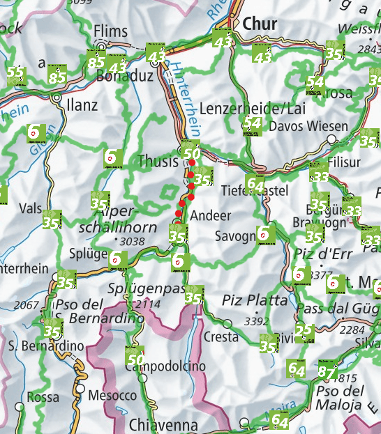
The website Schweizmobil provides clear maps of all major trails in Switzerland including the Via Francigena Renana shown as Path 50 on this extract from Chur to Chiavenna.
Chur (Coira)
Chur itself is well worth a visit as the capital of the Grisons and also possibly the oldest city in Switzerland. Ambra’s guide states:
Chur has a very old and well conserved centre with beautiful medieval towers, remains of the ancient walls, museums, well-kept modern areas, lots of green space, a lively cultural life and a thriving cultural and sporting tourism.
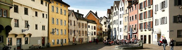
The centre of Chur, capital city of the Grisons and said to be the oldest city in Switzerland.
Via Spluga (Stages 2 to 5)
This section takes you through the most dramatic Alpine landscape. The Via Spluga is an ancient trail that has served for centuries in linking the towns of Thusis and Chiavenna, and the Graubünden, Rhaeto-Romansh, Walser and Lombard peoples. Most of the Via Spluga winds along mule tracks, where the original structure is largely maintained or has been restored. The total length of Stages 2 to 5 is 65 kilometres. Starting from Thusis (720 metres above sea level), it crosses the famous Via Mala gorge to Splügen (1457 m). From Splugen it turns south, going up to the Splugen Pass, which is the highest point of the route at 2,115 metres. From here, the descent begins, crossing the entire Spluga Valley and down to Chiavenna at 333 metres.

The Via Mala Gorge. This path is one of the options for traversing the gorge.
Mary Shelly described the route taken by her in 1840 in ‘Rambles in Germany and Italy’ published in 1844:
The road that traverses the Via Mala gorge through a series of single span bridges as noted by Mary Shelley in 1840
“A few years ago, there was no path except across this mountain, which being very exposed, and difficult even to danger, the Splügen was only traversed by shepherds and travellers of the country on mules or on foot. But now, a new and most marvellous road has been constructed – the mountain in question is, to the extent of several miles, cleft from the summit to the base, and a sheer precipice of 4,000 feet rises on either side. The Rhine, swift and strong, but in width a span, flows in the narrow depth below. The road has been constructed on the face of the precipice, now cut into the side, now perforated through the living rock into galleries: it passes, at intervals, from one side of the ravine to the other, and bridges of a single arch span the chasm. The precipices, indeed approach so near, in parts, that a fallen tree could not reach the river below, but lay wedged in mid-way. It may be imagined how singular and sublime this pass is, in its naked simplicity. After proceeding about a mile, you look back and see the country you had left, through the narrow opening of the gigantic crags, set like a painting in this cloud-reaching frame. It is giddy work to look down over the parapet that protects the road, and mark the arrowy rushing of the imprisoned river. Mid-way in the pass, the precipices approach so near that you might fancy that a strong man could leap across.”

Mary Shelley had followed the Via Francigena Renana from Coblenz as far as Colico but from there she took the Viandante down to Lecco in order to cross over to Bergamo before returning to Milan.
Via Francisca (Sixth Stage)
This section of the trail takes us from Chiavenna to what historically would have been the top end of Lake Como in the comune of Samòlaco. The origin of the name Samòlaco is said to stem from the Latin Summus Lacus or ‘the end of the lake’. Samòlaco is a comune without a major urban centre and so it may be best to identify this stage as ending at Dascio. Starting from Chiavenna at 333 metres, the section runs for 22 kilometres ending at Dascio (159 metres). Ambra includes plenty of detail along the route of the various items of cultural interest including the suggested brief diversion to visit the chapel illustrtaed below where one of the founding warrior saints of Como, San Fedele, met his end back in the third century.

The small Romanesque chapel of San Fedelino was constructed on the site where San Fedele was said to have been killed back in the 3rd century. His bones were taken up from this site and carried to Como where they were kept in the Basilica San Fedele. They were later transferred to Milan on the orders of Cardinal Carlo Borromeo.
The name ‘Francisca’ has nothing to do with ‘Francigena’. Instead it apparently stems either from medieval French for ‘to cross’ – franchir, or possibly ‘franc’ meaning safe from piracy because it was public and well-known.
Via Regina (Seventh to Tenth Stage)
The Via Regina takes us from Dascio to Como travelling down the western shores of Lake Como from the moment it arrives at the present-day head of the lake at Gera Lario. The whole length of this section is 75 kilometres and walkers get to appreciate the changing aspects of the lake and the tourism associated with it from top to bottom.
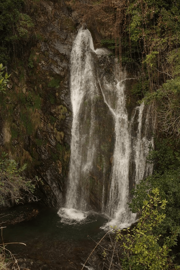
The Camoggia waterfall on the Antica Strada Regina near to Colonno.
As with the name ‘Francisca’ the name ‘Regina’ needs clarification since it does not relate in any way to regina as in Queen or owe its origin, as some think, to Regina Teodolinda, the Lombard Queen whose famous iron crown is held on display in Monza Cathedral. Instead the name stems from ‘Strada Regia’ meaning the main route or principal public path, as in the name used for the trail that leads from Brunate above Como to Bellagio.
Iubilantes, the association responsible for the current rediscovery of the Via Francigena Renana from Chur to the Po, can also take credit for identifying the course of the ancient Via Regina thanks to their major role in a cross-border Italo-Swiss project called ‘I Cammini della Regina’. This project has provided maps and signposting along the route, as well as an online application to assist walkers. Many may also be aware of a route known as the Greenway which follows part of the Via Regina through the comune of Tremezzina. Even if these different trails may have their individual variations, they all essentially form a part of the Via Francigena Renana – with all paths eventually leading to Rome!
Cammino di San Pietro Martire (Stages Eleven and Twelve)
Saint Peter Martyr was the prior of the Dominican convent complex known as San Giovanni Pedemonte which lay outside the walls on the western side of the city. It was demolished by Napoleon’s troops at the turn of the 19th century. Como’s main train station was built on the site and takes the name of San Giovanni.
This last section takes us from Como to Cantù and on via Seveso to Milan, the capital city of Imperial Rome from the third century. The route takes its name from a Dominican Friar, St. Peter of Verona, who headed the convent of San Giovanni Pedemonte on the western edge of Como. This convent was eventually destroyed by Napoleon’s troops during their brief occupation of Northern Italy but treasures and paintings from the church can still be seen in Como’s art gallery. Saint Peter was murdered on his way from Como to Milan just outside of Seveso by assassins sent by disgruntled landowners. Needless to say, the work of rediscovering this ancient route was not easy as it makes its way through all the modern day development that has formed around the ancient nuclei of Brianza’s communities. The result makes it still possible to walk these ancient paths and still gain some sense of the atmosphere of the past and to reacquaint oneself with the pace and rhythm of ancient travel, in spite of traversing what is essentially an extension of the Milanese conurbation.
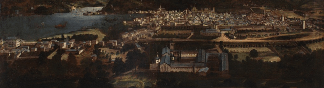
No greater is this impression of gaining an insight into the past than when walking the section through Milan as it passes by one significant historical monument after another, making evident from amongst its modernity, its importance since Imperial Roman times as a key European cultural, religious and economic centre.
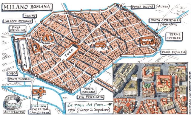
Milan, the capital of Imperial Rome from the third century.
Walking the Via Francigena Renana
![]() The Iubilantes guide is indispensable for those wanting to trek the section from Chur through Lombardy via Como. In addition to directions, it also lists places to stay or eat and identifies all places of geological, cultural or historic interest worth visiting along the way. It even suggests short diversions from the main route wherever there is something worth seeing via a brief detour.
The Iubilantes guide is indispensable for those wanting to trek the section from Chur through Lombardy via Como. In addition to directions, it also lists places to stay or eat and identifies all places of geological, cultural or historic interest worth visiting along the way. It even suggests short diversions from the main route wherever there is something worth seeing via a brief detour.
The book is available online from Edicicloeditore at €16.50. The same publishing house have also printed guides for the main Via Francigena. However, for the Via Francigena Renana, those interested can also obtain Ambra’s book directly from Iubilantes at a discounted cost by contacting the association via email at iubilantes@iubilantes.it. You can also download the set of GPX files covering all 15 stages described in the book from the Edicicloeditore site to load onto any trekking app such as Komoot.
Needless to say, the signposting for the Via Francigena Renana is a lot more thorough in the Swiss than in the Italian sections. From Chur to Splugen, the route is identified as path 50. There are also some very informative and practical Swiss websites to assist trekkers, such as https://www.viaspluga.com/en/itinerario/via-spluga/ or https://www.schweizmobil.ch/en/summer.html. The Schweizmobil site also offers an app to download to help you plan and track your hikes.
For the Via Regina, go to http://viaregina.como.polimi.it/laps/mobile.html#mappage to download an online map to computer or mobile phone.

Title page of a 16th century publication of the Itinerario Antonini listing the main routes established during the Roman Empire.
The route north from Milan to Chur was documented in the third century in the Itinerario Antonini which was a collection of routes established in Imperial Roman times but not mapped. The first graphic representation of the route across the Alps is in the Tabula Peutingeriana now kept in the Viennese Hofbibliothek. This map is essentially a graphical representation of the routes identified in the Itinerario Antonini without however any attempt at geographical accuracy other than including some obvious natural features such as Lake Como shown as the blue rectangle in the middle of the extract illustrated below. In this extract we can see Mediolanum (Milan) shown to the right of the lake and Como and Chiavenna shown above it on the route leading horizontally to Chur (Coira).

This is an extract showing Milan (Mediolanum) and Como on the Tabula Peutingeriana duplicated in 1598 from an original made in either the 11th or 12th centuries which itself was a copy of a map made in the times of Charlemagne based on a Roman original.
Further Reading
A number of walks that follow the Via Regina have been described in Como Companion including:
Walking the Greenway and the Antica Via Regina
Intrepid Exploration: Brienno to Laglio on the Via Regina
Our article entitled Lake Como: The 19th Century Super Highway describes the importance of Lake Como as a strategic communication link over the Alps through the centuries.
Iubilantes
![]() In addition to the research done on the Via Francigena Renana, the Cammina di San Pietro Martire and the Via Regina, Iubilantes have also published a large number of multi-lingual brochures describing some of the key religious sites in our area. They are also responsible for a very useful set of online walking guides around Como and nearby cities known as ‘CamminaCittà’ and available via this link.
In addition to the research done on the Via Francigena Renana, the Cammina di San Pietro Martire and the Via Regina, Iubilantes have also published a large number of multi-lingual brochures describing some of the key religious sites in our area. They are also responsible for a very useful set of online walking guides around Como and nearby cities known as ‘CamminaCittà’ and available via this link.
For more information about this association visit their multi-lingual website at iubilantes.it where you can also view a list of their publications which, if still available, can be requested by contacting the association directly via mail at iubilantes@iubilantes.it
This guide can be bought at a discount by contacting Iubilantes directly otherwise by purchasing online via Amazon.it or the publisher, Edicicloeditore.


Julian, I don’t know if you know about the exhibition in the Doumo about the Via Francigena Renana?
https://www.oggiacomo.it/eventi/Via-Francigena-Renana-scorci-e-suggestioni/
LikeLike
Thanks Monica, I’ll ensure I visit it.
LikeLike