From Griante to Colonno

2. Sanctuary of San Martino
The lake and its western shores have formed part of an vital Pan-European line of communication since Roman days. The summer jams on the main road, as it struggles through the constrictions from Colonno through Sala Comacina and on to Ossuccio, may cause you to doubt its former efficacy. Yet just above the main road there are the traces of the Antica Via Regina – the road that linked Milan to the Alpine passes and on to the valleys of the Rhine and Danube. Our walk takes us on a particularly picturesque section of this route whose former importance for commerce and religious pilgrimage to Rome is being researched by an Italian-Swiss project called the ‘Cammini della Regina’.
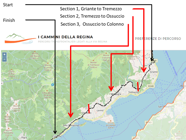
Antica Via Regina from Griante to Colonno courtesy of Cammini della Regina
Away from the frustrated traffic at lake level, the section of the route between Griante (Cadenabbia) and Colonno is particularly interesting and evocative. Additionally, in an imaginative initiative aimed at getting tourists to explore the hinterland behind the lakefront, the local councils have defined a walking route known as the Greenway. This takes in some parts of the Via Regina and so the signposting for both the Greenway and Cammini della Regina are relevant to us. The two routes do diverge in parts with the Greenway always offering a less strenuous (but possibly less rewarding) option.

Section 1: Griante to Tremezzo
I have divided the walk into three distinct sections using maps extracted from the geoportal of the Cammina della Regina website (viaregina.eu).
Section 1: Griante to Tremezzo

1. The beach at Griante. The walk starts by taking the road up hill from the bus stop at the beach.
Our walk starts off beyond the end of the Greenway at Griante. I got here taking the C10 bus out of Como and alighting at the third stop in Griante alongside the beach and at the base of the road leading up to the San Martino Sanctuary.
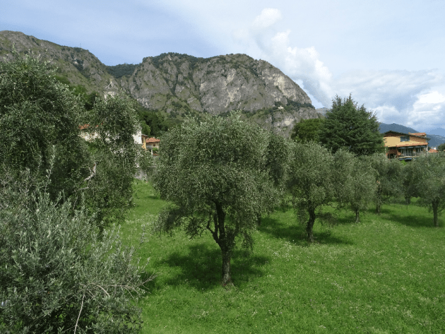
3. Olive trees in Griante – evidence of the mild microclimate created by lake and mountain.
The route here runs behind one of the most affluent tourist areas on the lake dominated by large villas and luxury hotels on the lakefront. However, step back a bit from the water and you soon find a much calmer, relaxed and timeless atmosphere much appreciated for its tranquility in times past by the ex-Chancellor of the German Federal Republic, Dr. Konrad Adenauer, who bought a holiday villa up in Griante in 1957 – the Villa La Collina– which now operates as an Italo-German cultural centre and hotel.

4. Griante donkeys
Since the route at this stage is relatively straight forward, it offers a good opportunity for acclimatising to the ‘Cammini dell Regina’ signage. The light blue plastic stickers are quite small and beginning to fade with age.
 However the eye soon becomes accustomed to picking them out. It is useful that usually after a potentially ambiguous turn, a sticker is strategically placed twenty or so metres further on confirming you are still on the right track. Whilst some parts of the walk are on asphalt, it mostly follows the ancient mule tracks made of cobble.
The zone here above the lake and below Monte Nava is primarily agricultural. The particularly mild microclimate also allows for the most northerly production of olive oil in Europe with the number of olive groves increasing as we go south towards Nesso. Nesso olive oil is one of the typical agricultural products from Lake Como and much valued.

5. Lunch with a view – on the terrace of La Fagurida
There are two or three restaurants to chose from as the road begins to dip down towards Tremezzo. I stopped at La Fagunda and sat on their small but panoramically positioned terrace overlooking the lake below. These are not ‘menu del giorno’ establishments though so wait until you reach Mezzegra (next section) if on a budget.
Section 2: Tremezzo to Ossuccio
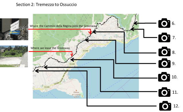
Section 2: Tremezzo to Ossuccio

6. Walking down towards Tremezzo
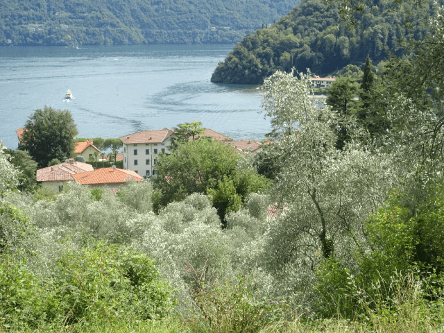
This section of our walk is dominated by the view down towards Lenno and its bay formed by the peninsula known as the Dosso di Lavedo. This is better known for the villa at its promontory, the Villa del Balbianello.
The walk takes us down to the valley and then heads back up hill through the mediaeval community of Intignano to arrive at Bonzanigo, a ‘frazione’of Mezzegra. At this point, the Cammina della Regina joins the more stately Greenway for a couple of kilometres. The Greenway is very clearly signposted with the distinctive yellow arrow on a blue background in addition to steel plaques laid into the paving from time to time. However the Greenway turns back down to our left half way along Via Pola Vecchia. The Cammini della Regina continues along the asphalt road until it turns back into a cobbled mule track to descend and cross another ancient stone bridge.

7. View to Lenno and the Dosso di Lavedo

8. Bonzanigo – where the Via Regina joins the Greenway

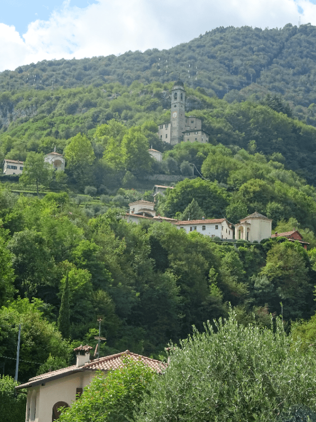
9. Church of Saint Abbondio, Bonzanigo
10. Olive trees above Lenno
A visitor sharing part of the walk with me enthused over the ‘real Italy’ he was experiencing which of course implied a lack of reality elsewhere. Rationally this comment does not compute since there is an infinite number of realities including those offered by the luxury hotels on the lakeside. However the Greenway and the Antica Via Regina take you through history along tracks used previously for hundreds of years, even past the house where, comparatively recently, Mussolini and his mistress spent their last night alive – and for me, it’s that strong historical perspective that supercharges the sense if not the actual ‘reality’ of the walk.

11. Masnate towards the Aquafredda Abbey
12. Towards Ossuccio’s Sacro Monte and Sanctuary
This section comes to an end as we pass by the road up to the Aquafredda Abbey and not long after reaching the first chapel in the series of chapels forming the Sacro Monte di Ossuccio. It is of course well worth taking the detour up the Sacro Monte passing the chapels along the Via Crucis to arrive at the sanctuary.
Section 3: Ossuccio to Colonno

Section 3: Ossuccio to Colonno

13. Bell tower of Saint Agatha
The landmark in front of us now as we descend from the base of Sacro Monte is Isola Comacina, the only island in Lake Como. It had a massive strategic value during the Middle Ages since whoever had possession of the island could also control all lake traffic north and south to and from Como. As a result Isola Comacina has had a turbulent history with the most dramatic event being its bombardment and destruction by Como and the allies of the Holy Roman Emperor, Federico Barbarossa. The destruction of the Milanese garrison in 1169 is recreated in a stupendous firework display every year at the end of June as part of the Sagra di San Giovanni.

14. Lakefront at Spurano – a ‘frazione’ of Sala Comacina facing onto Isola Comacina
Just before reaching the level of the main road, the Cammini della Regina joins up again with the Greenway and their two routes remain unseparated up to our final destination in Colonno.

15. Church of San Giacomo on the lakefront at Spurano
One has to admit that the towns of Colonno, Sala Comacina and Ossuccio betray little of their true beauty from the main road. Rather they give an impression of blight created by vehicles far too big for their narrow streets. However this is an entirely false impression and a much more accurate idea is conveyed by the approach to Sala Comacina on our walk which immediately crosses the main road to descend down to the lakefront through a labyrinth of narrow passageways.
The path passes by another Romanesque gem, the Church of San Giacomo. The series of Romanesque religious structures along on our route does more than anything else to convey the sense of those early small lacustrial communities – an impression of a long-past ‘reality’.

17. Isola Comacina from above Sala
The final stretch of the combined walkways starts once we again cross over the main road and make a gentle climb above the level of the lake. Our final descent towards Colonno reveals the true beauty of its location looking south towards Argegno.


The total distance of this walk is about thirteen or fourteen kilometres. Time taken depends to what extent you are distracted by so many possible diversions. The route marked out by the Cammini della Regina includes three stretches of prolonged climb which are all avoided by the Greenway. However the increased altitude does ensure more spectacular views out over the lake – and a greater degree of tranquillity. Whichever option you go for, rest assured you will be walking in the steps of so many ancestors and the shadows of their former presence will undoubtedly impact your sense of ‘reality’. After all, you will have traversed part of one of Europe’s earliest super highways – the so-called Romweg, or Road to Rome!

Extract from the Romweg or ‘Road to Rome’ published in Germany in 1498 showing the route from Edinburgh to Rome with the map oriented from South to North.
