The Roman bridge at Argegno over the River Telo.
This circular walk begins and ends at Argegno, a delightful town on the western shore of the Como leg of the lake and at the start of the Valle d’Intelvi. This valley links Lake Como to Lake Lugano or to use the original latin names of the lakes, from Lario to Ceresio. The Valle D’Intelvi has a natural beauty derived from spectacular features such as the majestic Monte Generoso and the Sassa Gordona which both straddle the Swiss border. The Telo runs down the eastern section of the valley into Lake Como while the similarly named Telo di Osteno runs westwards beyond Pellio into Lake Lugano. The proximity of the lakes and the abundant irrigation from the streams running down from the mountains on either side create a unique mild micro-climate which was much appreciated by those Milanese industrialists who built their Liberty-style villas here well away from the suffocating summer heat and humidity down in the Pianura Padana.
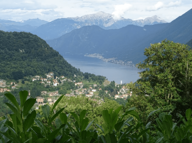
View from the path from Veglio to Giuslino down on to Rovasco and Lake Como.
This area also has a remarkable creative tradition having produced artists and craftsmen who have had a major influence on European culture in two distinct eras, the first being from the ninth century and on through the period of Romanesque architecture and the second during the seventeenth century in the period of the baroque. So an excursion up the Telo Valley offers opportunities to appreciate both art and nature while passing through the medieval centres of a variety of mountain villages.

Church of San Sisinio, established originally in Roman times, This was the view painted by Winston Churchill on his holiday to Lake Como in 1945.
Argegno is easily reached from Como either by bus (C10 or 20) or by boat. From the main piazza, take any of the narrow alleyways off to the north and cross the Roman bridge following signs for the Mulattiera di Pigra, a cobbled ancient path that will lead us up above the town to Muronico. After a brief climb you will see the Church of San Sisinio on your right. This is one of the oldest churches in the valley originating from the days of the original Roman settlement of Argegno. The interior of many of these churches in the Valle D’Intelvi host impressive internal decoration dating from the baroque period. For example, San Sisinio has a great example of the fake marble mosaic work developed by the valley’s craftsmen called ‘scagliola’. Unfortunately the churches are mostly left locked but don’t hesitate to enter if you see an open door. You will always be welcomed to look around unless of course there is a service being held.

Chiesa di Sant Sisinio, above Argegno – Winston Churchill, from sketches done in July 1945
As you walk up the mulattiera past the church look back to appreciate the very viewpoint adopted by Winston Churchill when he painted the church during his holiday on Lake Como in 1945 after the war and his recent defeat in the post-war general election. The path will lead you on into the old centre of Muronico where you should try the doors of the Chiesetta di San Carlo which houses other fine examples of Intelvi craftsmanship.
The walk described here is one recommended by an association known as the ‘amici di Dizzasco e Muronico’. They publish a handy leaflet with a clear map available in any of the tourist offices with the long but descriptive title ‘Percorso suggestive di esplorazione culturale e paesaggistico della Bassa Valle d’Intelvi’. The same association is presumably also responsible for the clear signposting provided at least for the first section of the walk from Argegno to the Via dei Mulini outside of Dizzasco. However, signposting gets more challenging once you cross the Telo river and make your way up to Cerano.
 The route up the valley takes you past Muronico, past the turning off to the right for Pigra to Rovasco, followed by Biazzeno and then Dizzasco. Dizzasco is a town obsessed with mules hosting an annual Mule Festival and displaying mule emblems in some most unlikely places.
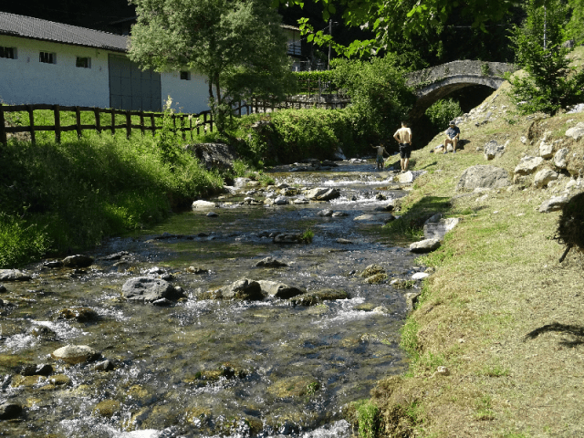
The River Telo at the recreation area on the Via dei Mulini outside of Dizzasco. Our path takes us across the bridge in the background to start a climb up to Cerano.
Take the left-hand forks out of Dizzasco’s main piazza to descend down to the Via dei Mulini where there is a picnic area along the banks of the Telo. It is well worth taking a brief detour before crossing the bridge by taking the river side path going up the valley. A five minute walk will bring you to an old mill followed shortly after by another mill on the far side of the river.
When you cross the bridge you start to climb out of the valley towards the town of Cerano. Before making a gradual return down this other side of the Telo Valley, you can detour up a further hundred metres in altitude to the neighbouring town of Veglio before following the signs for Giuslino.

Mule water spout on the fountain in Dizzasco – the town which hosts the annual Festival of Mules
There are few opportunities to eat along this walk but, if arriving around lunch time, Cerano’s Baby Bar offers a fixed price lunch for €12 including wine, water and coffee with a first and second course of mountain proportions – a very good deal. You may well need this refuelling stop if you decide to walk up to Veglio. The route is not signposted but take the road north out of the town and then turn left where you see a road with a sign warning of a 10% gradient. When in Veglio, head south past a lavatoio (the old communal laundry facilities which are still used by some in these mountain communities). The tarmacked road soon gives way to gravel and then a cobbled mule path offering some great views to your left down to the lake below. However, once you follow the sign for Giuslino, look out for an un-signposted sharp turn left and downhill. If you miss that turn you will carry on to the path leading up to the spectacularly located Church of San Zeno – a seriously long way off your route and a very steep climb!

Fresco on the walls of the lavatoio in Veglio. Unusual in that the subject is domestic rather than religious.
Coming out of Giuslino you are forced to follow the main road south until you come to a bridge known as the Ponte Erboggia. The Erboggia is a tributary of the Tela. A notice beside the bridge explains its strategic importance and the plans to blow it up in the case of invasion from across the border in the First World War. This road is the only way into the south side of the Telo Valley from the west and blowing up the bridge would essentially prevent any further access east towards Argegno.
Turn off the tarmacked road at the bridge and then follow the mule path south avoiding any turn off to San Zeno until you come out of the woods and approach the Church of Santa Maria Assunta above Schignano. Schignano is a town that hosts a truly fascinating carnival in February.

Clouds following a summer storm surround the mountain-top church of San Zeno
Over the years the carnival has attracted more and more attention across Lombardy mainly since it is a true piece of street theatre as well as an opportunity for the local people to demonstrate their skills in carving wooden masks. Despite its growing popularity, it has remained true to its anarchic origins since its organisation is entirely in the hands of the local community who exclude outside commercial interests.
The route from hereon is downhill taking you down to the Sanctuary of Sant’Anna perched above Argegno. Here there are a couple of restaurants and I can give a personal unqualified recommendation for the Locanda Sant’Anna where the food is excellent but by no means as economical as Cerano’s Baby Bar!
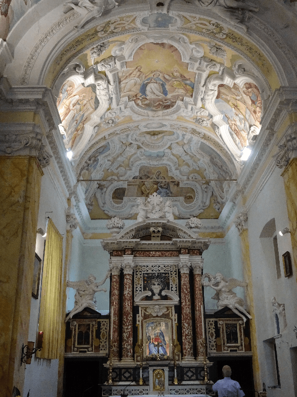
Interior of the Sanctuary of Sant’Anna, below Schignano on the path down to Argegno. The rich decoration shows off the skills of the Intelvi artists and craftsmen in the baroque style of fresco painting and sculpture.
The signs state that the descent from Sant’Anna to Argegno will take about forty minutes from where you can take the bus from the main piazza back to Como.

The town of Schignano
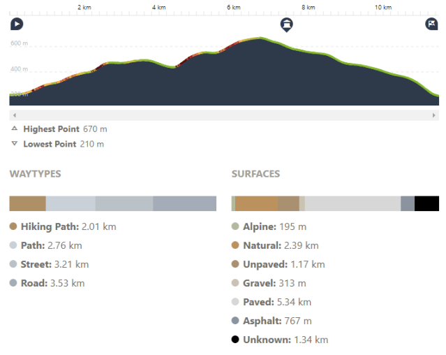
The map provided in the tourist office states the entire route amounts to around ten kilometres but, given the slight lack of adequate signposting from Cerano, allow for a few more. Argegno is at about 220 metres above sea level and Veglio, the highest point on the walk, is at 700 metres. However you need to allow plenty of time for the walk given all the glorious cultural attractions along the way.
I find the history and culture of the Vale D’Intelvi fascinating so there are a number of other articles in this blog if you would like to read more. They include:
- Como’s Artistic Tradition – A Pan-European Legacy: Maestri Comacini
- Stucco and Scagliola – Two of Como’s Baroque Specialities
- Lords and Ladies of Misrule at Schignano

SUMMARY

Distance: 11.5 km
Time: 3.47 hrs
Climb: 520 metres
Descent: 520 metres
Difficulty: Difficult – good fitness required