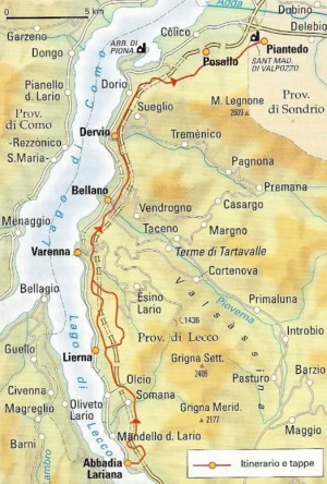
The Via del Viandante (Wayfarer’s Way) is a long distance trail that runs up the eastern leg of Lake Como from Abbadia Lariana to Colico. However it is misleading to think of this as a single path in the same way as the Antica Strada Regina or the Strada Regia on the Como leg. Instead the Via del Viandante is a series or networks of paths ranging in the quality of their signposting and in the difficulty or gradient of the terrain.

The Via del Viandante runs up the Lecco leg of Lake Como from Abbadia Lariana to Colico
Starting out from Abbadia you can easily be misled by the clearly demarcated and well surfaced path as it climbs gently through olive groves into thinking your route to Colico will be as well marked along its entire course. Not only do the signposts desert you at critical moments but the number of possible alternative paths all heading roughly in your desired direction force the realisation that this is not a single ‘via’ but a series of ‘vie’. But the variety and views along your way will more than compensate for these momentary inconveniences.
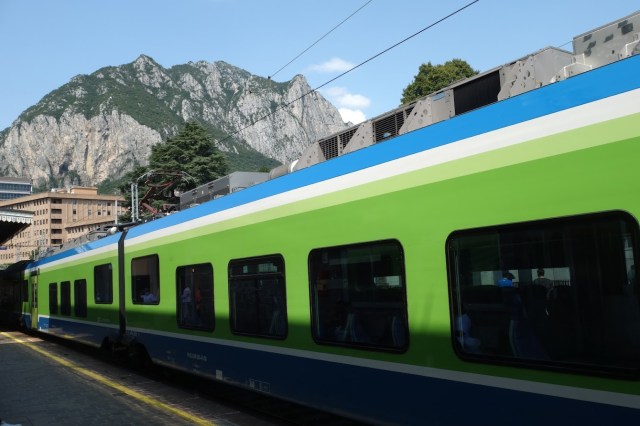
Setting out from Lecco Station – the train line linking all the main towns along the Lecco side of the lake offers walkers the flexibility of adapting their excursions at any time.
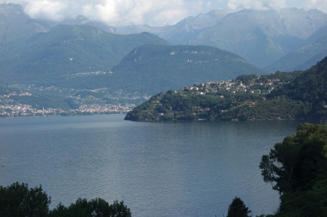
It is perhaps the variety of the terrain, the landscape and the vegetation which go to differentiate this path from those on the Como leg of the lake. All visitors on arrival at Lecco can immediately appreciate the difference in the terrain with Mount Resegone with its jagged peaks looming over the city. Further north the impressive mountain range of Le Grigne dominates the landscape with its foothills providing a steep challenge particularly to those hiking between Varenna and Mandello. These natural pinch points to communication encouraged the building of castles and towers close to the main towns along the route including the Castello di Vezio above Varenna, the delightful castle ramparts at Corenno Plinio as well as the strategically placed Torre di Orezia at Dervio protecting access to the Valvarrone.

The Torre di Orezia in Dervio
Those of you more accustomed to hiking on the Como leg of the lake will also note how many more full rivers and streams you traverse along the Viandante. These range from what is billed as the shortest river in Italy – the Fiumelatte – to the numerous streams or rivers that traverse the Grigne and flow down to the lakeside towns. In Bellano the combined effect of erosion caused by the Pioverna and the ice age glacier of the River Adda created a deep gorge and a series of dramatic waterfalls now known as the Orrido di Bellano – perhaps the most dramatic series of waterfalls to be seen on Lake Como. These ample and reliable sources of water, gathered over extensive watersheds descending the mountain ranges to the north and east, gave towns like Bellano and Dervio the power needed for early industrialisation. Most of these industries have now moved on leaving behind their abandoned structures and the intricate series of mill races and irrigation channels that fed power to them.

An olive grove in Olgiasca.
The major challenge of the Via del Viandante is managing the ‘dislivelli’ as you descend down to a valley or rise up to an alpine pasture. But these variations in altitude provide considerable variety in vegetation with olive groves at lakeside level rising to now un-managed chestnut terraces and upwards through woods on to alpine pastures with all open areas generously dotted with wild flowers even in the height of summer. In fact the abundance of wild flowers here is another of those more obvious contrasts with walks on the Como leg. Maybe this is down to some significant geological difference that ensures a more reliable supply of water.

Olgiasca – on the road to the Abbey at Piona
Those of you familiar with staying on the Como leg of the lake will be more than aware of the narrow roads hardly able to handle the volume of traffic in the summer months. You will not experience anything like that on the Lecco side which profits from a much more extensive communications infrastructure. There is a major highway whisking traffic from Lecco away from the lakeside roads on a direct route to the Valtellina. The Via del Viandante traverses this road on a few occasions creating moments of marked contrast between the calm pace of the ‘wayfarer’ compared to the frantic cacophony on the highway. The lakeside terrain also seems broad enough in most parts to allow for local roads of sufficient width. These towns also profit from the railway line that links all of the communities to Lecco and onwards to Milan or north east to Sondrio and the Valtellina. This railway is a great advantage to hikers offering the opportunity at any stage to terminate or shorten any excursion. Yet this part of the lake is less developed for tourism with notable exceptions such as Varenna or Corenno Plinio. This should not limit any hiker though from finding suitable accommodation along the route since there are a number of family-run hotels or Bed and Breakfast places not just along the lakeside but also in the small mountainside communities. There are also a number of rifugi for those wanting to walk the peaks of Le Grigne. All in all, the Via del Viandante gives you the chance to experience the beauties and characteristics of this part of Lake Como offering constant variety along the way. As such, for me it proved the ideal trail for a multi-day excursion along the majority of its course from Piona to Abbadia.

The range of Le Grigne mountains provides a dramatic backdrop to the Via del Viandante
Starting Out
I decided on tackling the Via del Viandante over three days and nights going from north to south. Rather than selecting Colico as the natural start or end of the trail, I decided to start slightly off piste at Olgiasca so I could take in the Cistercian Abbey of Piona before heading out south.
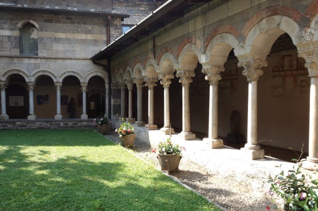
The cloister of the Cistercian Abbey of Piona
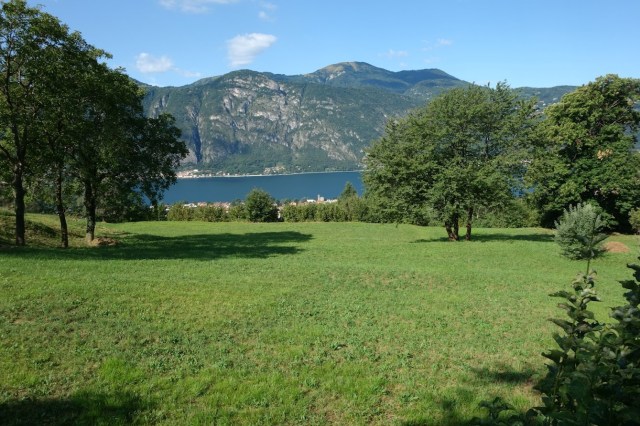
Travelling from Como to Lecco on public transport is not as swift as one might prefer with the choice of a slow bus ride or a train journey requiring a change at Monza. The train does however offer the option from Monza of continuing on to Mandello del Lario from where one could just take a leisurely and unchallenging stroll back past Abbadia to follow the lakeside walkway to Lecco. However on reaching Lecco I took the slow train to alight at the nearest point to Olgiasca – Dorio. After a stretch walking on the lakeside road, footpaths lead you up to the small and tranquil town of Olgiasca perched on a promontory and facing south with great views down the lake or north towards the Val Chiavenna and the towering mountains either side of it.

Detail of medieval carving at Piona
The abbey is a brief two kilometre walk from the town along an easy cobbled road offering great views along its way. I was expecting the abbey to be perched in a particularly panoramic spot on the promontory but this is not the case. However the simplicity of the Romanesque architecture, the remains of some very early frescoes and the charm of the multi-columned cloister all made up for this initial disappointment.
I stayed overnight in the simple, clean and welcoming Hotel Belvedere in a room with a great view over the lake. I ate out at the Agriturismo Malacrida on the path towards the abbey. It offers a fixed menu at a fixed price of €35 which includes wine, water and coffee. The view on their terrace is glorious but not so the cuisine which was more marked by its abundant quantity rather than its quality. The wine was particularly uninviting.

The terrace at Agriturismo Malacrida looks towards the Val Chiavenna
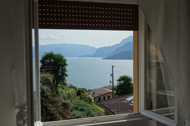
View from the room at the Hotel Belvedere
Day 1: From Piona to Bologna

First day’s walk from Piona to Bologna
The following morning, once I had retraced my steps back to Dorio, I turned off the road and started my own version of the Via del Viandante. The well-signposted trail soon rose steadily to reach the calm above the lakeside and to gain even better views over the water.
View looking back north to Olgiasca
The start of the day was easy with no major climbs or descents with the route well signposted. I soon crossed over one of the many mountain streams I would encounter over the next three days. The path, having passed through woods, olive groves and open pasture dips down to the lakeside at Corenno Pliniano – one of the prettiest small towns on Lake Como.

Corenno Plinio – one of Lake Como’s medieval jewels.
Corenno seems to be a town that stopped all further development after the Middle Ages thus keeping in tact the narrow alleys and steep paths descending from the church and castle to the water. One oddity for English visitors to note is the dedication of the town’s church to Thomas A Becket, the luckless Archbishop of Canterbury assassinated on the orders of King Henry II. The church is well worth a visit as is the whole town itself.

The mill race at Dervio – the vital source of power for the town’s early industries.
From Corenno, the path climbs back up the hillside to continue its steady and relatively effortless course towards Dervio dominated by the Torre di Orezia. Here the archeological interest is provided by the old industrial structures of the late nineteenth and early twentieth century and the water courses running off from the River Varrone which used to power them. One cannot help but note the abundance of water along the Viandante which provided the power needed in those early years of industrialisation and factory production. Nowadays water power is still important here but as the means for generating hydro electricity.
Climbing back up from the lakeside and following another delightfully easy stretch through woods and orchards, the path descends down to Bellano. Bellano has a very particular and spectacular attraction for tourists – the dramatic series of gullies and waterfalls known as the Orrido di Bellano.
After Bellano I began to realise I had made a bad mistake in planning my route. I had always looked at the profile of the path with some concern when noting the marked ascent on the day’s latter stage as it climbed from lake level to Bologna. I had also not taken into account that the route here was on a rudimentary hiking path. This marked ascent would always have been a challenge but one I would have been more prepared to manage if not on a multi-day excursion carrying a full backpack from stop to stop. It was hard going. It was with considerable relief that I finally reached my overnight stop in the old mountain community of Bologna, a village just further up the mountain side from Perledo.

The view south from Bologna taking in Vezio in the foreground, Bellagio and the fork in the lake.
I stayed at a pleasant Bed and Breakfast called ‘C’era una volta’ in the centre of the old town. It offered everything I needed after a full day’s walking including a cold beer on arrival. Feeling completely exhausted, I was also glad to learn that the local restaurant was a mere 50 metres away and fortunately the quality of both the food and wine was considerably better than that experienced the day before. The stay at this welcoming B & B completely restored my desire and ability to take on the next day’s excursion although, given the weight of the backpack, I decided to alter my plan to climb up to 1000 metres by hopping on the train from Fiumelatte to Lierna.
Day 2: From Bologna to Somana

The route from Bologna to Somana above Mandello passing by Coria with a maximum altitude of 780 metres above sea level
As on the previous day, this day’s walk started off easily with a descent down to Perledo looking down directly on Varenna and to Bellagio on the promontory which marks the fork in the lake. The Castello di Vezio lay ahead perched above Varenna in a commanding position with views to the north, south and west. The castle is well worth a visit due not just to its glorious location but also to look into the aviaries housing the castle’s collection of birds of prey. I chose not to head down into the centre of Varenna or to visit the house and gardens of the Villa Monastero. Instead I followed the so-called Greenway dei Patriarchi to Fiumelatte. This stretch was one of the most beautiful along the entire length of the Viandante, leading to the River of Milk (Fiumelatte) billed as the shortest river in Italy.

The Greenway dei Patriarchi running down from the Castello di Vezio to and beyond Fiumelatte.

The source of Italy’s shortest river – the Fiumelatte.
Then, fearful of the 1000 metre climb up on to the flanks of Monte Fopp (and unaware at the time of an alternative route via Coria which only reaches 750 metres), I waited patiently at Fiumelatte’s train station to go one stop south to Lierna. However, a platform announcement just five minutes before my train was to arrive informed me of its cancellation and the imminent departure of the bus replacement service leaving from ‘the usual point’. I had little faith in catching this replacement bus even if I knew where the usual bus stop was given that the station was nowhere near the main road. I later learnt I was right to doubt the very existence of such a bus. Perhaps only in Italy can such announcements be made with all locals fully aware of their fictional nature. August is a busy holiday period and no doubt the train was unavailable due to staff shortages – an issue as likely to effect the bus service. The replacement service was a pure phantom. So I decided to continue on following the Greenway dei Patriarchi which conveniently ran on from the end of the station platform. I should have noted a turn off to the left putting me back on the Via del Viandante towards Coria but didn’t. When the Greenway dei Patriarchi fizzled out on the border of the Comune di Varenna I had no other choice but to walk along the lakeside road as far as Lierna.

The beach area at Lierna
Lierna itself did not appear to have much to offer other than its extensive beach which was well frequented. I was grateful though at this point to return onto the Via del Viandante and, following a gradual uphill slope, to finally reach Somana. Somana retains a small medieval sector but is predominantly modern. It hosts a significant hydro-electric plant. All told, not a spot I would recommend except for one significant factor – the excellent Agriturismo La Selvaggia where the food is divine and the price very low.

Nothing better than a taste of heaven after a long day’s walk – very economical and excellent quality at the Agriturismo La Selvaggia
In any multi-day excursion there are bound to be highs and lows and although Somana and my accommodation were themselves a disappointment, my evening meal was anything but. La Selvaggia, for a visitor, is hard to find. It is about a 20 minute walk up a mule path above the village in a clearing in the woods with a view over the valley to Mandello and beyond. There are no signposts to lead you there but clearly the owners have no need of publicity to attract their clients. When I arrived on a Sunday evening, every single outdoor place had been booked and I had to content myself within the rustic interior.

The interior of tLa Selvaggia
For me the height of culinary quality is to be found in traditional mountain dishes done exceptionally well. My first evening’s meal in Piona was an example of traditional local food offered without any inspiration. The whole experience at La Selvaggia was the total opposite. They have paid attention to every aspect of the culinary experience with the same attention to detail and consistency that you might expect from a Michelin-starred restaurant. Their fixed menu takes you through the typical Agriturismo offer of antipasti, two different first courses, a main course with polenta, pudding, coffee, water and wine. But from the moment the wine arrives and the antipasti placed on the table, you begin to appreciate that this is no standard fare. The usual offer of bresaola, salami, lard and prosciutto was lifted into the divine by three varied home made sauces. The quality of the pasta dishes was superb. I passed on the polenta and wild boar to go straight to the dessert, and here comes the difference. The three different types of dessert came offered with a glass of sweet sparkling moscato. No wonder so many of the villagers were prepared to take a 30 minute walk up and down an unlit mule path to fill this restaurant on a Sunday evening.
Day 3: From Somana to Abbadia Lariana

The route on he third day from Somana to Abbadia showing the diversion along the Valle Meria with No. 1 showing the crossing over the river.

The tributary joining the Meria just by the bridge for traversing the valley.
The last day of the excursion was to be the easiest and the shortest of walks to allow time to return by train to Como. On starting out just below the Agriturismo La Selvaggia, I soon made what turned out to be a fortunate error by missing the right hand turn off the Sentiero del Fiume to cross the valley over to Rongio. Instead I carried on the delightful path following the course of the valley of the Torrente Valle Meria.
I again missed the final path off to the right to cross the Meria only to ford the river just 50 metres further up by walking over the weir. With wet feet I then walked back down the other side of the valley immediately noting where I could have kept feet dry by crossing the bridge until I finally reaching Rongio a good hour behind schedule. Time was no matter and I would recommend this diversion for the beauty of the valley and its fast flowing river and tributaries. With views of the lake concealed, the landscape was dominated by the mountains in the Le Grigne chain rising to their jagged peaks just under 2000 metres high.

Le Grigne dominate the views on the third day of the walk.
From Rongio, the views along the walk were again dominated by the lake and the town of Abbadia below. The descent was easy and as the terrain flattened out, became dominated by green pasture and olive groves. Here the signposting of the Via del Viandante is clear and unequivocal and, when skirting Abbadia itself, even the cobbled path has Viandante as its street name.
The gentle slopes through pasture and olive groves towards Abbadia.
The signposting for the route now extends south to Lecco itself by following the recent cycle and pedestrian path built directly on the lakefront. However my plan had always been to terminate my excursion at Abbadia, to take the train from there to Lecco and hence via Monza to Como. However it was at the Information Office in Abbadia’s railway station that I learnt about the fictional nature of any advertised bus replacement service. No train was going to stop at Abbadia going south to Lecco. Instead I had to go one stop north to Mandello but at least from there I was able to catch a direct train south to Monza. And so ended this particular mini-holiday which had enabled me finally to appreciate the beautiful characteristics of the Lecco leg of the lake in all its variety.

Journey’s end at San Martino looking south towards Lecco
Recommendations
When planning this walk I had underestimated my level of fitness and capacity to undertake some of the steep climbs with a full backpack. So I would recommend either adjusting the route to avoid these climbs or arranging for the bulk of your baggage to be shipped each day to your overnight stay. I have seen that some companies do organise trips with this facility but the charges seem unnecessarily high. I am sure local taxis could arrange this at a modest cost.
As I experienced, the signposting is not consistent across the length of the walk in spite of the best efforts of the Pro Loco Lario in defining and promoting the route. GPS coverage does not reach everywhere. Only satellite navigation can be guaranteed.
Some sites do not recommend undertaking the walk in the height of summer due to the heat. I had no problems due to heat but did experience those issues with staff shortages on the railway due to summer holidays.
Finally I can heartily recommend the Via del Viandante for a multi-day long excursion due to the fascinating variety along the way, the beauty of the landscape and the ability to truly get away from it all.
If anyone would like copies of the GPX files covering the routes taken over the three days of the walk, please message me.