

Above mist and cloud, ‘on top of the world’ at the summit of Monte Bisbino (1325m)
Monte Bisbino is Como’s local mountain. At 1325 metres above sea level – comparable to Ben Nevis in UK – it certainly is not the highest around the lake but it is one of the most significant. How come? It’s partly due to the border with Switzerland that runs across its summit which made it one of the favoured routes for smugglers in former years. The ‘contrabandisti’ also acted as guides on the so-called ‘viaggi di salvezza’ during the war where they helped Jews, allied prisoners of war, partisans and other enemies of the state to escape into Switzerland for safety from the nazi-fascist regime.
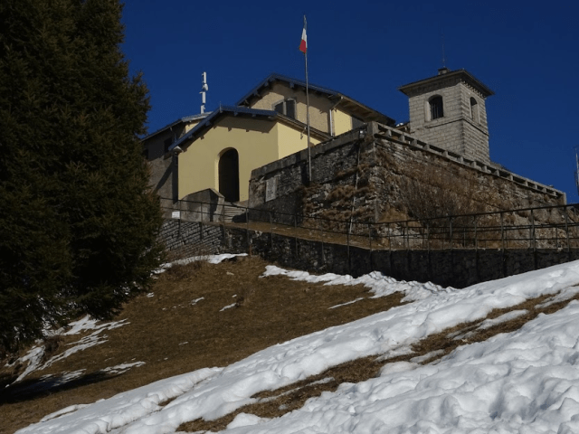
The rifugio and the Sanctuary to the Blessed Virgin on the summit of Bisbino
Its summit houses a ‘rifugio’, a sanctuary and also well-preserved trenches and fortifications built as part of the Cadorna defences during the First World War. The fear then was that the Austro-German army could decide to ignore the neutral status of Switzerland and march through its territory to invade Italy on the Lombardy borders. In reality, the fighting took place exclusively on the North Eastern side of the country and the Cadorna Line in Lombardy was never put to the test.
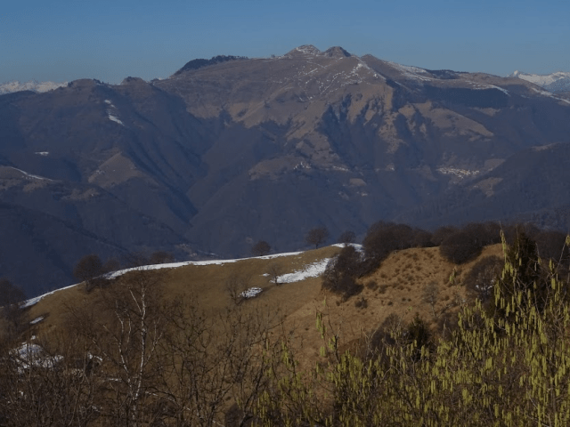
Monte Bisbino’s neighbouring mountain, Monte Generoso, seen from Bisbino
A climb to the summit is an achievement in itself and, depending of course on the weather, is likely to be rewarded with a glorious 360 degree view including looking north along the line of the border past Sasso Gordona and Monte Generoso.

Sasso Gordona, another summit with extensive fortifications from the First World War.
The trek up the mountain is on well-defined paths kept in good order and not requiring any specialist equipment. The paths are well signposted thanks to the volunteer members of the Rovenna Pro-Loco. However be sure to take appropriate clothing since there is often a significant variation in temperature at the summit with snow still likely to be present on the north-facing slopes well into April. Take plenty of water with you on the uphill journey since there are few if any springs on the route selected here.
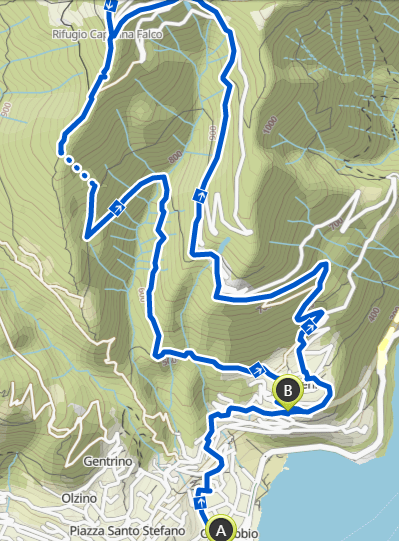
There are in fact various routes up the mountain depending on whether you start from Cernobbio or from the Swiss side of the border. From Cernobbio, you could take the route from Piazza Santo Stefano that passes close to the ‘Croce del Uomo’ to then pass Piazzola and follow the line of the border along an extensive ridge before making the final ascent. This is shown as SI-SC on the map below. The other options are from the other district of Cernobbio, Rovenna. From Rovenna I prefer to take the route that goes via Madrona and crosses the mountain road to the summit a couple of times. This is shown as CAI-1 below. There is no easy way to the top other than driving up but this latter route is in my opinion the least arduous with the safest paths. However, for the sake of variety here I describe an alternative route for the descent that takes you past a gushing spring with a year-round abundance of delightfully cool and clean mountain water.

The path marked in yellow is the route described for the ascent whilst green is used for the descent.
If arriving by car, you can drive up to Rovenna and leave the car in a good-sized car park just beside the cemetery. Otherwise, from the centre of Cernobbio (Piazza Mazzini) walk directly up the hill alongside the car park which covers the stream. You will then pick up the signs for Path 1 which will guide you up to Rovenna following Via Monte Grappa. Alternatively you can turn off to the right at the start of the car park to walk along part of the original Via Regina, passing by the Giardino della Valle and then climbing up to Rovenna on Via Monte Santo.

As you climb up to Rovenna you will begin to see the large yellow signs for Monte Bisbino provided by the Rovenna Pro-loco, as here on Via Monte Grappa.
Once in Rovenna you cannot miss the large yellow signs erected by the Pro-Rovenna group pointing you to Monte Bisbino. Rovenna is known for staging a witches festival in autumn coinciding with the height of the chestnut season.

Trenches on the summit – part of the Cadorna line defences
It also has the Gatto Nero restaurant renowned for high prices, celebrity customers and a marvelous view over the lake – not somewhere just to drop in for a coffee and a sandwich. For this there is a bar in the village’s main square beside the bus terminal for the very infrequent bus service down to Cernobbio.
By taking any path uphill and keeping to your right whenever faced with an option, you will at some point meet up with the well established mule path leading up to the first small hamlet outside of Rovenna. This is the mountain community of Scarone. There is a spring here thoughtfully installed for trekkers in the past but which has unfortunately now stopped working – hence the need to bring adequate supplies of your own. It will take you about an hour to get from Cernobbio to Scarone.

Scarone
Continue following the well-defined and relatively broad mule path as it makes steady uphill progress through the woods before breaking out onto the alpine pastures that mark your entry into the mountain village of Madrona – a thirty minute climb from Scarone. The village of Madrona is named after the foothill of Bisbino with the same name. Here you join the tarmacked road up to Bisbino for about a kilometre before leaving it to take the broad mule path that goes off to the left as the road makes a sharp bend to the right. Along this section you start to get some clear views towards the summit of Bisbino. The path continues to climb but initially less steeply but the gradient does gradually increase as you continue.

The view opens up just after Madrona showing the pine woods which mark the last strata of vegetation before the summit.
The next time you traverse the tarmacked road will mark the final section of the ascent. At this stage the mule path becomes less broad and the gradient decidedly steeper. You soon enter the band of pine trees which crown these southern slopes of the mountain’s summit. If the path gradient becomes too onerous, you can always opt to follow the longer but less arduous road whenever the path traverses it. You will also soon see signs advertising another ‘rifugio’ – Rifugio Bugone – leading off to your right. That rifugio is on a line and path called the ‘Via dei Monti Lariani’. It follows the crest of the mountains and the border leading to and beyond Rifugio Prabello having passed a number of other buildings which, as with the rifugi, were all originally barracks for the border guards seeking to prevent smuggling.

The second to last traverse of the mountain road at the start of the last section where you enter the pine woods.
The final ascent of the summit takes you through a part of the pine forest which has been recently cleared leading you round onto the western facing slopes and the Capanna Falco. It just requires one last effort to climb up the open grassland to reach the summit and a well deserved rest and possibly something to eat and drink if arriving on a day when the rifugio opens. Opening times are however dependent on the season so check via website prior to departure to avoid disappointment. Don’t be too surprised to find the restaurant doing good business at the weekends since most of the clients would have arrived by car. However you will also see singularly exhausted-looking cyclists who, like you, have made it to the summit under their own steam! Expect to take at least one hour and a half to reach the summit from Madrona, or to summarise, three hours in total from Cernobbio.

Twin peaks of Monte Generoso
As you look out to the north and to the twin peaks of Monte Generoso, it is interesting to note that this neighbouring mountain now provides a base for a herd of wild horses that used to live on Bisbino. These horses were moved over to Monte Generoso a few years back when the harsh winters started to bring them into conflict with local inhabitants as they descended the mountain looking for food. The decision was taken to round them all up and migrate them to Generoso and, what is more, to ensure their well being during the winter months by escorting them down to lower pastures where the locals could more readily ensure they had enough to eat and drink. Their story is told in this delightful video clip on You Tube which includes the story of the old mule who was relocated along with the horses but who, on sensing he was dying, took it upon himself to return to Bisbino for his last days.

The Capanna Falco – a rifugio run by an association for use by its members.
Now for the descent. The start of the route selected for the descent is not marked so take care to find the right point of departure. As you retrace your steps towards the Capanna Falco, note the start of a path running alongside the fence of the building immediately before the refuge. This is the path to take. It soon begins to descend the grassy area quite steeply passing alongside the gardens of a private building before entering into the woods. Once entering the woods, it then re-emerges briefly onto a much broader path with multiple signpostings.
 At this stage, you should follow directions previously for Duello but for Fonte Anzone once marked. Once past more private gardens, the broad path reduces down to a narrow strip as it re-enters the woods. You are no longer going to be taking an actual mule path until you reach the Alpetto Gombee so be sure to look carefully to discern the route of the path as it descends through the woods looking in parts very much like the course of a mountain stream. Also look out for a critical sign pointing you to the Alpetto Gombee and Fonte Anzone. This will take you off to your left and will soon lead you to the small alpine clearing of the Alpetto.

Alpetto Gombee (850 metres)
It is at this point that you pick up on an ancient mule path recognisable by the stone and cobble surface and the occasional stretches of dry stone wall. The paths on the descent are nowhere near as well defined as those followed on the climb up so even though you are now on a mule path, it is not well used or well maintained. However, as you get lower and lower, the path does become clearer and certainly by the time you reach the Fonte Anzone, it is back to normal standards. It will also lead you back to Rovenna eventually where you can cross the village to get to the car park if needs be or descend to Cernobbio by either Via Monte Santo or Via Monte Grappa.

All year round fresh water at the Fonte Anzone
This descent takes almost as long as the climb up and, in the early stages, is a little difficult particularly if the ground is wet. However it does mean that you would have taken a slightly circular route to provide variety. Of course you could decide to reverse your options and ascend via Fonte Anzone and descend via Madrona. That would be more arduous in my opinion. The Fonte Anzone route goes through more woodland and is not as varied in views and terrain as the way we took up. Also bear in mind that this path in its upper reaches is quite steep and not so well defined.

Young deer seen in the woods above the Fonte Anzone
Whichever route you do decide to take, you will end the day with a great sense of achievement and, hopefully weather permitting, fond memories of the views along the way and at the summit with that unique sense of being for a few moments ‘on top of the world’.
SUMMARY
Distance: 13.3 km
Time: 5.14 hours
Climb: 1,100 metres
Descent: 970 metres
Difficulty: Expert Hiking – Very good fitness and sure-footedness required.

