My motive for visiting Lake Montorfano was to swim in its beautiful, clean, super-tranquil water since nothing feels better than swimming in the wild! And it’s even better if the swim is at your destination after an hour’s walk through shady woods. The only challenging aspect to this walk is the eccentric signposting – but I have sought to compensate for that through a series of photos to show the main stages on the route to the lake. I have left it to your own ingenuity to make your own way back!

Lake Montorfano
Lake Montorfano was created as part of the glacial retreat which formed the mountains surrounding Como and the moraine deposits such as Monte Goj just to the west of the lake. It is the first and smallest of a string of smaller lakes that stretch out between Como and Lecco through the north of Brianza. No major roads pass it and there is little development along its shores. It is so very much smaller than Lake Como which makes it entirely different in nature – a much more intimate space, unbelievably tranquil where the only sounds normally heard are the cries of the waterfowl as they traverse the water.
To get there, take the No.7 bus from Como centre in the direction of Lora to the end of the line. From there you have an hour’s walk through woods to get to the lakeside. (You could also take the No. 6 bus in the direction of Brebbia alighting at Albate to pick up the path through the Valbrasca). Start by crossing from the bar by the bus stop and walking to your right past the ‘Casa di Gino’. Immediately after the Casa di Gino you see the turning shown in the photo below on your left. The yellow arrow shows the entry to the footpath that runs between the two tarmacked roads.

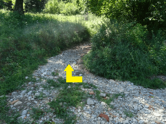
Step 1: As in all these images, follow the yellow arrow.
After a short while, there is a turning off to the left that you should follow. If you were to go straight on, the path will lead you up to Monte Goj and to a baita there that has a good reputation for its cooking.

Step 2: left at the graffiti-riddled sign
This path leads you down into the green flood plain of the Valbasca where you turn left (step 3) in the direction of the cemetery. In fact the path you are on is part of Via Cimiterio. If you were to turn right you will link up with the path that takes you along the delightful Valbasca to come out eventually at Albate.
As you approach the walls of the cemetery, turn to your right (Step 4) and continue until the dirt road you are on crosses the small river.


Just after the river crossing, the main path leads round to the right in the direction of the dog kennels that cannot be seen but can certainly be heard from here.

Step 5: Take the narrow uphill path marked by the arrow.
Step 6: The narrow path turns to the left and then has a chalk chip surface.
Keep to the stone chip path as it climbs uphill with woods on your right.

You might now begin to see yellow circle signposting along your route. Some of the circles are done with white paint and some of the circles are done with both! On other occasions you might just see a yellow or white ‘splodge’ of paint. In spite of the signposting not being too standard, they do direct you accurately.
The path continues along the northern edge of the woods with views to your left over towards Tavernerio and to the crest of the mountains by Brunate. It then enters the wood on all sides as you come up to the uprooted tree stump at a multiple path junction.

Step 7: At the uprooted tree stump, turn right and look for the yellow or white circle sign to confirm your route.

Step 8: The path comes to a crossroads with a more dominant dirt-track running left to right. Turn right.

Step 9: Follow the twists and turns of this road as it climbs gently uphill. Take a right turn when you reach this junction.

Step 10: You will begin to see a low concrete wall running along the lefthand edge of the road. Ignore the first turning to the left after which the concrete path is on your right. Instead take the second turning on the left ensuring that the concrete wall is now running on your left-hand side.

Step 11: Continue straight on along this well defined path as it runs on the level through the woods.

Step 13: You will come up to this fork in the path with border fencing on your left side and the woods on your right. Turn right here. There is a yellow paint sign to confirm your route.
If you overlook the turning at Step 13, all is not lost. You will go down a slope to join a larger path that leads on to a tarmacked section if you go to the left. Turn right and follow that path which will lead you directly on to Step 14. If you have followed Step 13, your path will get narrower and less succinct as it drops down a slope. As soon as you see a more defined path going left to right, turn to your right.

Step 14: Your path becomes more of a dirt-track road with garden walls and fencing on your lefthand side whilst the woods are still on your right. Continue along this stretch until you see an entrance way on your right as shown in Step 15.

Step 15: Turn off the dirt track and then immediately take the path to your left. This path then goes uphill briefly followed by an immediate descent to the lakefront.
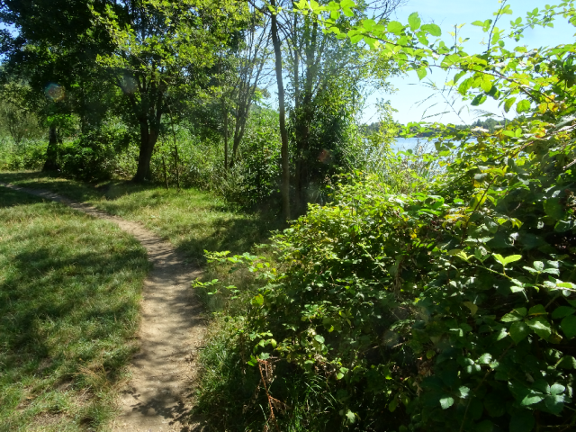
Step 16: You have now joined the footpath that goes around the lake. Turn left and you will come to a grassy area used by locals for swimming and sunbathing. Turn right and you come across small areas of beach good for swimming if not already occupied by fishermen.
If you follow the lake path to your right, you will eventually come across the Montorfano Lido which unfortunately has some rather negative reviews on Trip Advisor notwithstanding the beauty of the environment.


SUMMARY

Distance: 4.27 km
Time: 1.11 hours
Climb: 100 metres
Descent: 40 metres
Difficulty: Easy – suitable for all skill levels

